
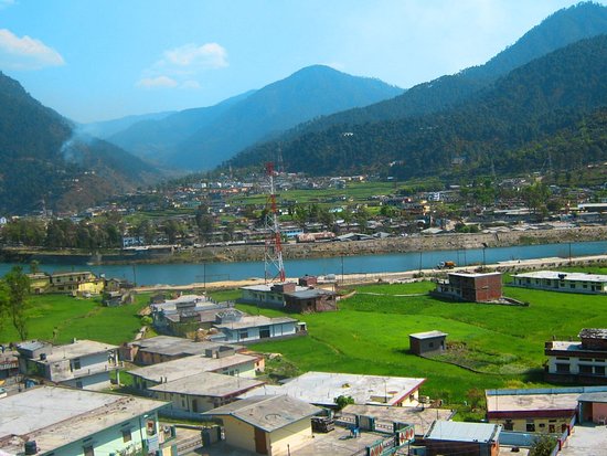
Uttarkashi district was created on February 24, 1960 out of what then constituted the parganas of Rawain and Uttarkashi of Rawain tahsil of erstwhile Tehri Garhwal district. It sprawls in the extreme north-west corner of the state over an area of 8016 sq. kms. in the rugged terrain of the mystic Himalayas. On its north lie Himachal Pradesh State and the territory of Tibet and the district of Chamoli in the east. The district is named after its headquarters town Uttarkashi, an ancient place with rich cultural heritage and as the name suggests is the Kashi of north (Uttara) held almost as high a veneration as Kashi of the plain (Varanasi). Both the Kashi of the plain (Varanasi) as well as the Kashi of north are situated on the banks of the river Ganga (Bhagirathi). The area which is held sacred and known as Uttarkashi, lies between the rivers Syalam Gad also known as the Varuna and Kaligad also known as the Asi. The Varuna and the Asi are also the names of the rivers between which the Kashi of the plain lies. One of the holiest Ghats in Uttarkashi is Manikarnika so is the one by the same name in Varanasi. Both have temples dedicated to Vishwanath.
History
Uttarkashi district was created on February 24, 1960 out of what then constituted the parganas of Rawain and Uttarkashi of Rawain tahsil of erstwhile Tehri Garhwal district. It sprawls in the extreme north-west corner of the state over an area of 8016 sq. kms. in the rugged terrain of the mystic Himalayas. On its north lie Himachal Pradesh State and the territory of Tibet and the district of Chamoli in the east. The district is named after its headquarters town Uttarkashi, an ancient place with rich cultural heritage and as the name suggests is the Kashi of north (Uttara) held almost as high a veneration as Kashi of the plain (Varanasi). Both the Kashi of the plain (Varanasi) as well as the Kashi of north are situated on the banks of the river Ganga (Bhagirathi). The area which is held sacred and known as Uttarkashi, lies between the rivers Syalam Gad also known as the Varuna and Kaligad also known as the Asi. The Varuna and the Asi are also the names of the rivers between which the Kashi of the plain lies. One of the holiest Ghats in Uttarkashi is Manikarnika so is the one by the same name in Varanasi. Both have temples dedicated to Vishwanath.
The terrain and climate of Uttarkashi district provide uncongenial physical environment for human settlement. Yet undaunted by hazards and hardships this land was inhabited by hill tribes since ancient times bringing out the best in man his adaptive talents. The hill tribes namely Kiratas, Uttara Kurus, Khasas, Tanganas, Kunindas and Pratanganas find references in the Upayana Parva of Mahabharata. The land of Uttarkashi district has been held sacred by Indians since ages where the seers and sages had found solace and spiritual aspirations and performed penances and where devas performed their sacrifices and Vedic language was better known and spoken than elsewhere. People came here for learning Vedic language and speach. According to an account given in the Mahabharata, Jada Bharatha a great sage performed penances at Uttarkashi. the Kedar Khand of Skanda Purna refers Uttarkashi and the rivers Bhagirathi, Jahanavi and Bheel Ganga. The district of Uttarkashi was part of Gharwal Kingdom ruled by Garhwal dynasty that carried the cognomen `Pal’ which was changed to Sah during 15th century conferred by Sultan of Delhi perhaps Bahlul Lodi. In 1803 Gorkhas of Nepal invaded Garhwal and Amar Singh Thapa was made Governor of this region. The Gorkhas came into contact with the British power in 1814 as their frontiers in Gharwal became determinous with those of the British. The border troubles prompted the Britishers to invade Garhwal. In April, 1815 Gorkhas were ousted from Garhwal region and Garhwal was annexed as British district and was split up into eastern and western Garhwal. The eastern Garhwal was retained by the British Government. The western Garhwal, lying to the west of the Alaknanda river with the exception of the Dun was made over to the heir of Garhwal dynasty Sudarshan Sah. This state came to be known as Tehri Garhwal and it was merged with the state of Uttar Pradesh in 1949 after India attained independence in 1947.
Geography
Lying in the upper Himalayas, Uttarkashi contains within itself varying geographic environments ranging from snow free valleys and outer hills to the high peaks with perpetual snow and glaciers. The terrain runs into series of ridges and valleys. Each ridge leads to another coiling up in seemingly unending chains.Most of the terrain is mountainous consisting of high rise ridges, hills and plateaus and flat pieces of land are rare. The land in these areas is now in fertility due to large content of out crops of boulders and gravels. Made-up of alluvial soil, valley is a stream bed. Generally forests occur on the upper ridges that bound the valleys. On their sloping hill sides lie a chain of sparsely populated settlements interspersed with terrace cultivation.
Nature expresses itself in breath-taking variations from beauteous landscape luxuriously decked with vegetation punctuated by streams, brooks and rivers to high rise awesome rocky ridges and mountains gently tapering off into lefty snow-capped peaks. The widely varying climate and topography produce a wise range of vegetation and serve as habitats to diverse species of wild life. Forests occupy a place of pride in the environment of the district not only for the sheer bulk of the area they occupy but also for the richness of variety of vegetation. As much as 88 percent of the total area of the district is administered by the Forest Department. Pine forests occur between the altitude of 900-2000 metres, Deodar forests between 2000-3000 metres, Fix and Spruce forests over 3000 metres and Kharshu, Birch and Junipers forests upto the height of 4000 metres. Above the Fir and Spruce forest zone, alpine pastures are found throughout the district between the height of 3500 metres to 4877 metres above sea level. Rich varieties of grass, shrubs and herbs come up during June- September while during the remaining part of the year these areas remain covered with snow. A large number of medicinal plants of great commercial value grow spontaneously in the forests. Some of these grow in the valleys, some in sub-montane tracts while some other on higher altitudes. Forestry too does play an important role in the economy of the district. It employs persons both in preservation and propagation of forests as well as in their exploitation. Herbs are the most important minor forest produce. A large variety of herbs grow wild.
RIVERS AND WATERWAYS
It is the land of Uttarkashi district that gives rise to two great and reverent rivers of India the Bhagirathi, called the Ganga in the plains and the Yamuna. The Ganga coming up in the glaciers `gaumukh’ traverses 128 kms. in Uttarkashi district before flowing down farther. The third important river of this district is Tons besides host of tributaries that drain these areas.
AGRICULTURE AND IRRIGATION
Agriculture in these areas suffer from many constraints. The availability of cultivable land itself is the greatest restricting factor on the development of agriculture. It can be seen from the fact that as much as 88% of the area is either covered by forests or is barren and uncultivable. The land is low in fertility except in the valleys and even land is too few and far between. Shorter agricultural season, low temperature, high altitude, smallness of land holding, perpetual problem of soil erosion due to steep gradients etc. are other inhibiting factors effecting agriculture. The agriculture, therefore, does not offer too much hope for bringing about well being to the people of the area. Sheep rearing for production of wool and meat, orchard raising, spinning and weaving of wool and other cottage industries etc. offer much scope and their potential be exploited to the fullest extent. The cultivation in these areas are carried on largely by making terraces on the sloping hillsides. Some cultivation is done on steep hills also where terracing and tilling cannot be done and the place is cleared by burning scrubs and bushes. The seeds are sown with the help of a hoe. This practice of cultivation is known as `Katil’. Both Rabi as well as Kharif crops are harvested. The main Kharif crops are paddy, small millets and potato and chief Rabi crops are wheat and barley. These crops account for over 80 percent of the total cropped area. Horticulture is another field that can boost up the economy of the district. However, it has not made much headway due to difficulties in marketing the produce, due to poor communications and remoteness of areas.
ANIMAL HUSBANDRY
Animal husbandry is an important source of supplementing income of the rural population. Of the total live-stock, bovine population and that of sheep accounted for almost one third each. The production of milk per milch animal is very low. Efforts are under way for introducing high yielding strain. Sheep rearing is an important industry in the district. Yet it does not provide full time employment and it is only avocation for those who are engaged in its pursuit.
INDUSTRIES
The knowledge regarding occurrences of minerals in the district is scanty. As per stray surveys, soap stones, iron, graphite, lime stone, kyanite and mica deposits occur in the district. There has been hardly any industrial development in the district. The cottage and village industries play an important role in the economy of the district. The most important cottage industry is the production of wool and woolen goods. Sheep are reared in a large number and the industry flourished at an altitude between 1525 metres and 2440 metres. Carpets (namdas), tweeds, blankets etc. are produced. Other cottage industries are basket-making, mat weaving and wood craft. The potentials of forest and horticulture can be better exploited by locating forest and horticulture based industries within the district. This will bring down transportation cost as a proportion to the selling price of the products, making them competitive in the market. Tourism industry possesses tremendous possibilities of development. The terrain produces some of the rarest spectacles contrasting between awesome raggedness and breath takingly beautiful landscape which have charmed and challenged man since ages. The location of Hindu religious places takes it beyond the pale of connoisseur and lovers of nature to the common man who throngs for religious satiety.
Flora And Fauna
Due to the inaccessibility of the region and relatively fewer human habitations, the flora and fauna in the district are abundant. The forest cover is in the region of 60 – 80%,, housing a bewildering variety of trees, flowers, wild animals, birds, fish and butterflies.
Trees of various kinds are found in different altitudinal ranges, for which they are best adapted. Between 1,000 – 2,000 m., the forest cover is almost exclusively of pine. The pine flowers between February and April, the seeds being shed in October. Pine trees are tapped for resin and their dry leaves used as manure. The biggest pine tree in Asia, with a height of 60.5 m., is found at Khoonigad, en route to Arakot from Mori.
Between 2,000 m – 3,000 m. are found forests of deodar, oak and rhododendron. Deodar (from the Sanskrit, deva – daru, divine – tree) is used for building temples. The wood from oak and rhododendron is utilised for agricultural implements while their leaves serve as cattle fodder.
Beyond 3,000 m., forests of spruce, birch and fir are widespread. The bark of the birch tree (bhojpatra) was used in ancient times for recording manuscripts, some of which are still in excellent condition. Between 3,500 m-4,500 m. occur the bugyals, with a rich variety of flowering shrubs.
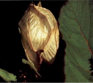
The bugyals are especially noted for their wild flowers, which carpet the hill – sides for miles on end. Of these, the most beautiful is the rare blue poppy, of which Frank Smythe had this to say -‘In all my mountain wanderings, I have not seen a more beautiful flower’. Also called ‘hemkamal’ or snow lotus, its silky – blue petals radiate serenity. Another celebrated blossom is the Brahmakamal, or ‘the lotus of Brahma.’ Often used for religious observances, this large flower is sweet – smelling and found in the higher reaches beyond 3,000 m. The flowers of the Rhododendron family, red, pink or white, set hillsides ablaze between February and April. Syrup from the flowers is extremely tasty, but some varieties are poisonous.Several medicinal herbs and plants are found at higher altitudes and in the valleys. Near Nelang village, extensive tracts of padam can be found. The powdered wood of this shrub is used for ‘havan’ purposes because of its perfume. In the Dayara range are found atish and guggool, used in medicine manufacture. The crushed leaves of the Chiraita shrub are believed to banish fever in minutes. Another useful plant is the Semru, which exudes a milky substance that produces light when ignited.
The jungles and forests harbour a rich variety of wild – life, some of the chief categories of which are given below:
Among the felines found are the snow leopard, leopard, tiger, leopard cat and civet cat. Of these, the most elusive is the snow leopard, with a coat of pale misty grey.
Of the bear family, both the Himalayan Black Bear and Brown Bear are present. They are good tree climbers and can be quite aggressive when disturbed.
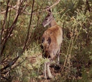
Among the antelopes, the most prominent are the bharal, serow, musk – deer barking deer (kakar) and sambhar. The bharal is found at altitudes of around 3500m such as Nandanvan,and is extremely agile and nimble. The musk deer are being hunted for musk – pods and are now quite rare.
Among reptiles, a wide variety of snakes are seen, many of whom are worshipped as nag devtas. Another striking specimen is the monitor lizard, a good 2ft. in length, called goh or gumla in the local dialect.
A large number of rodents, such as squirrels, marmots and rats, can be observed. Marmots are common in the Har – Ki – Dun area, where their presence can be detected by their high – pitched, chittering voices. They store food in their burrows and hibernate through winter.
The wide diversity of bird – life is distributed according to the altitude. Among the pheasants found here are the kalij, kokla, chir and monal. The monal with its resplendent plumage of metallic green, glistening purple, startling red and jet – black, is a sight to behold. It moves about in small groups and takes flight when one almost stumbles upon it.
Among partridges, the Himalayan snow cock, kala titar and chakor are frequently sighted. The kala titar or black partridge frequents shrubs near cultivated land. The chakor loves open hill slopes and also visits cultivated fields in search of grain.The pigeons and doves that inhabit the area are the harial, the fakta, and the malyo or blue rock pigeon. The harial is a yellowish – green bird found in oak forests. The fakta is a large dove while the malyo has a slaty grey colour with a metallic lustre.
The non – game birds generally sighted are the magpie, thrush, paradise fly – catcher, parakeet, golden oriole, sunbird and robin. The birds found near water courses are the brown dipper, plumbeous redstart, spotted fork – tail and wagtails. Various swifts, skylarks, swallows, warblers, bulbuls, mynahs and other smaller birds add to the rich bird – life of the district.
Fish are plentiful in almost all the lakes and rivers, except at high altitude. Trout in Dodital and carp in Nachiketatal are in abundance. Besides, the mahaseer, kalhana and goonch lurk in the shadowy depths wherever river – water collects.
Butterflies are generally seen in bugyals and near flowering shrubs. Some of the prominent are: Peacock Pansy: Golden brown with large spots, it is found in low lying, moist areas.
Blue – Peacock: Deep black and metallic blue in colour, with red spots, it makes a striking appearance.
Tawny Raja: This species has a dark brown tipped outer wing, with inner zones of light brown colour.
Red Lacewing : It is bright brown in colour with a dark brown lace – like fringe.
Large Silverstripe: It is commonly seen on flowering shrubs, having yellow wings with brown polka dots.
Great Orange – tip: Its wings are half white and half brown in colour.
Red – base Jezebel: It is brown with white, yellow and red markings.
Yellow Pansy: Found in the lower reaches, it is brown with four large yellow patches.
Red – Helen: It is reddish brown in colour with one white patch on each wing.
Saturn – Moth: This is a beautifully coloured nocturnal creature, found at higher altitudes.
Culture & Heritage
The district is named after its headquarters town Uttarkashi, an ancient place with rich cultural heritage and as the name suggests is the Kashi of north (Uttara) held almost as high a veneration as Kashi of the plain (Varanasi). Both the Kashi of the plain (Varanasi) as well as the Kashi of north are situated on the banks of the river Ganga (Bhagirathi). The area which is held sacred and known as Uttarkashi, lies between the rivers Syalam Gad also known as the Varuna and Kaligad also known as the Asi. The Varuna and the Asi are also the names of the rivers between which the Kashi of the plain lies. One of the holiest Ghats in Uttarkashi is Manikarnika so is the one by the same name in Varanasi. Both have temples dedicated to Vishwanath.
The terrain and climate of Uttarkashi district provide uncongenial physical environment for human settlement. Yet undaunted by hazards and hardships this land was inhabited by hill tribes since ancient times bringing out the best in man his adaptive talents. The hill tribes namely Kiratas, Uttara Kurus, Khasas, Tanganas, Kunindas and Pratanganas find references in the Upayana Parva of Mahabharata. The land of Uttarkashi district has been held sacred by Indians since ages where the seers and sages had found solace and spiritual aspirations and performed penances and where devas performed their sacrifices and Vedic language was better known and spoken than elsewhere. People came here for learning Vedic language and speach. According to an account given in the Mahabharata, Jada Bharatha a great sage performed penances at Uttarkashi. the Kedar Khand of Skanda Purna refers Uttarkashi and the rivers Bhagirathi, Jahanavi and Bheel Ganga. The district of Uttarkashi was part of Gharwal Kingdom ruled by Garhwal dynasty that carried the cognomen `Pal’ which was changed to Sah during 15th century conferred by Sultan of Delhi perhaps Bahlul Lodi. In 1803 Gorkhas of Nepal invaded Garhwal and Amar Singh Thapa was made Governor of this region. The Gorkhas came into contact with the British power in 1814 as their frontiers in Gharwal became determinous with those of the British. The border troubles prompted the Britishers to invade Garhwal. In April, 1815 Gorkhas were ousted from Garhwal region and Garhwal was annexed as British district and was split up into eastern and western Garhwal. The eastern Garhwal was retained by the British Government. The western Garhwal, lying to the west of the Alaknanda river with the exception of the Dun was made over to the heir of Garhwal dynasty Sudarshan Sah. This state came to be known as Tehri Garhwal and it was merged with the state of Uttar Pradesh in 1949 after India attained independence in 1947.
Languages in Uttarkashi : Garhwali & Hindi.
Arts in Uttarkashi : Woolen clothes made from sheep’s wool,Wooden sculptures, eco freindly baskets etc.
Garhwali music are the traditional music enjoyed by Uttarkashi people.
Fairs in Uttarkashi : Cultural fairs, religious fairs like famous Magh Mela and Sainik Mela , Krishi Mela organisez by District Adminsitration Uttarkashi as it invite people of all disciplines to rejoice the occasion. Being the district headquarters these fairs attract large number of visitors and tourist from and the district.
TOURISM
Gangotri Dham , Uttarkashi
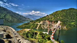
Gangotri, the origin of the River Ganges and seat of the goddess Ganga, is one of the four sites in the Char Dham pilgrimage of Uttarakhand. The river is called Bhagirathi at the source and acquires the name Ganga (the Ganges) from Devprayag onwards where it meets the Alaknanda. The origin of the holy river is at Gomukh, set in the Gangotri Glacier, and is a 19 km trek from Gangotri.
Yamunotri Dham
Yamunotri is the source of the Yamuna River and the seat of the Goddess Yamuna in Hinduism. It is situated at an altitude of 3,293 metres (10,804 ft) in the Garhwal Himalayas in District Uttarkashi. It is one of the four sites in Char Dham pilgrimage of Uttarakhand. The sacred shrine of Yamunotri, source of the river Yamuna, is the westernmost shrine in the Garhwal Himalayas, perched atop a flank of Bandar Poonch Parvat. The chief attraction at Yamunotri is the temple devoted to the Goddess Yamuna and the holy thermal springs at Janki Chatti (7 km. Away).
Harsil
Dharali/ Harshil Valley: At 2660 mtrs the Harshil valley offers complete contrast with what one finds in summers. streams gets frozen and black tarmac gets hidden under a thick white carpet.
Gomukh
Gomukh is the source of the Bhagirathi River in Gangotri Glacier, one of the primary headstreams of the Ganges River. The place is situated at a height of 13,200 ft (4,023 m) in Uttarkashi district.
Dayara Bugyal
Dayara Bugyal is grass land starting at 2600 mtrs and goes upto 3500 mtrs. The 9 kms of trek through the woods and rhododendron tress takes one to this pristine place, in summers the shepherds reach here with their cattle and stay till the onset of winters. in winters the meadows turn into snow land with potential of skiing and snow activities.
Nelong Valley
Nelong valley is a inner line area (India – China border) ,opened for tourist only for day time. It is approx 100 km from Uttarkashi HQ .
Dodital Lake
Dodital is a freshwater lake in uttarkashi district. Assi ganga rises from dodital and joins bhagirathi. The confluence is at Gangori. To reach Dodital, From Uttarkashi, a short jeep ride of 19 kilometers will take you to Sangamchatti from where the 24 km trek to Dodital begins. This is a mostly gentle trek, with overnight halt options at the village of Agora or Bebra. At Agora, which is 6 km from Sangamchatti, one can stay at one of the private lodges or alternatively, camp at Bebra which is 8 km from Sangamchatti. From there one can start the second leg of the trek the next day which will take you to Dodital via the small summer settlement of Manjhi.
Gartang Gali
This wooden bridge was the trade route between India and Tibet. the nomads (Bhotiya tribe) ferried their goods on yaks from this bridge for barter with their other country part.
